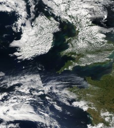
A stationary area of high pressure has meant that we’ve had dry and stable weather during the past week, with temperatures up to 27 °C on Wednesday, but a persistent layer of cloud has spoilt what would otherwise have been wall-to-wall sunshine for many. Aren’t high pressure systems meant to mean cloudless skies, so what caused this frequent cloud? Ironically, the answer is the strength of the high pressure itself and how it traps moisture underneath it!

In a standard atmosphere, temperature normally falls with height, at a rate of around 6.5 °C/km. Air warmed at the surface rises and cools, forming clouds. It will continue to rise as long as it’s warmer (less dense) than its suroundings.
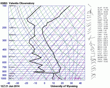
In an area of high pressure, however, it’s the opposite. Dry air is descending (subsiding) from upper layers, which prevents clouds from forming. As the air subsides it compresses and warms at a rate of 9.8 °C/km (just like a bicycle pump heats up through compression of the air inside), and this forms a warm layer (subsidence inversion) a few thousand metres up. Within this layer, temperature actually rises with height. This layer is also extremely dry, as the air originated from the cold upper levels of the atmosphere. This inversion is easy to see in the Valentia sounding below. This is a plot of temperature (right), dewpoint (left) and wind (arrows) throughout the depth of the troposphere, as measured by sensors attached to a weather balloon. Isotherms are diagonal lines connected to the bottom axis. The inversion starts just above 1500 metres, with temperature showing a sharp increase and dewpoint and relative humidity shooting downwards dramatically within just a few tens of metres. Just underneath the inversion is the shallow cloudy layer, where the temperature and dewpoing curves are very close together.


Any moisture in the lowest layer of the atmosphere is trapped below this inversion because any rising air parcels can’t penetrate further up into it. If condensation occurs below the inversion then cloud will form, and that is what has happened in some parts of the country this week, with persistent stratocumulus cloud reported at around 3,000-5,000 feet (900-1,500 m). The exact wind direction and location dictated the exact amount of cloud, with coastal areas mainly clear, and clouds forming further inland, where thermal energy was greatest.
We should see a few more days of this setup before the high becomes replaced by a more unsettled regime by midweek.
I thought it was just happening above me 🙂 It’s been crystal clear nights then dense cloud moving in by around 6.30 am, then remaining overcast until about 11pm. Today, at the moment, between Kells and Oldcastle, we have a crack or two in the clouds.
Yes, as those thermals die down in the late evening so do the clouds, so skies generally clear. Nice opportunities to see noctilucent clouds, which are at about 80-85 km altitude and are visible in the north only when illuminated by the sun below the horizon.
[…] So why do we sometimes get layers of cloud even in high pressure? This occurs when the lowest layer is moist and saturated near the inversion, with cloud forming but being forced to spread out by the warm air above it. The current airmass is very dry in its lowest layers, meaning it never reaches saturation, except when it forms fog at the surface during the nighttime cooling. This process is described in more detail in this previous article. […]