Of all the Irish windstorms in living memory, Debbie in September 1961 set many records that still stand to this day. With a total death-toll of 78 (18 in Ireland and 60 in a plane crash in Cape Verde), it left a path of destruction in its wake. It has been claimed that this storm was the only true hurricane to survive as far north as Ireland, but this is not the case. Hurricanes, in the true sense of the word, simply cannot hold onto their tropical characteristics throughout the long trek this far north, and Debbie was no different. It is possible for us to get regular storms with hurricane-force winds, but they are a different beast altogether. So what was Debbie then?
Tropical versus non-tropical.
Firstly, let’s define what a hurricane is, as this seems to be a cause of confusion. The National Hurricane Center defines a hurricane as a tropical cyclone with 1-minute sustained windspeeds of at least 64 knots, the name hurricane referring to such storms occurring in the Atlantic Ocean and the Pacific Ocean east of the International Dateline. They define a Tropical Cyclone as
A warm-core non-frontal synoptic-scale cyclone, originating over tropical or subtropical waters, with organized deep convection and a closed surface wind circulation about a well-defined center. Once formed, a tropical cyclone is maintained by the extraction of heat energy from the ocean at high temperature and heat export at the low temperatures of the upper troposphere. In this they differ from extratropical cyclones, which derive their energy from horizontal temperature contrasts in the atmosphere (baroclinic effects).
So a hurricane is a tropical cyclone, which is very different to the typical extratropical cyclones found at our latitudes. The following are the main differences:
- Warm core: the area at the centre of a tropical cyclone is warmer than the outer part due to air heating as it sinks down the eye. This feature is not found in extratropical storms.
- Barotropic: this means it does not feed off horizontal temperature gradients but off warm ocean surfaces, unlike our baroclinic extratropical storms, which get their strength from the difference between warm and cold airmasses.
- Location of strongest winds: in tropical cyclones the strongest winds are closest to the central eye and decrease outwards, whereas in extratropical cyclones they are usually further displaced from the centre.
- Central Dense Overcast (CDO): tropical cyclones have a (usually) symmetrical mass of high cloud covering the system, whereas extratropical cyclones have the familiar comma-shaped cloud signature.
- Vertical windshear: this is the increase of wind with height. Tropical cyclones need low windshear to maintain themselves whereas extratropical cyclones get much of their energy from strong jet stream winds at height.
- Rain bands: Tropical cyclones have rain bands that spiral outwards from the centre whereas extratropical cyclones have a warm, cold and later an occluded front, which are each different in their properties.
A tropical cyclone starts off as a cluster of showers and thunderstorms at low latitudes, usually south of Cape Verde or near the Caribbean. If the sea-surface temperature (SST) is at least 26.5 °C and windshear is low then this cluster can organise itself to form a circulation (Tropical Depression, <34 knots), which can further deepen to a Tropical Storm (34 kts or more) and ultimately a hurricane (64 kts or more).
If it remains over warm enough SSTs and shear remains low then it can continue to deepen as it moves generally westwards towards the Caribbean/USA. It will then encounter stronger westerly upper winds, which will start to steer it in a more northeasterly direction over the colder seas of the north Atlantic. The combination of colder seas and this increased shear from the upper jet stream causes it to lose its warm core, eye, etc., and it will either dissipate completely or morph into a frontal extratropical cyclone/depression. In some cases the jet stream can deepen this system again and continue it to high latitudes, with the residual moisture adding some spice to the mix.
This has happened on several occasions in Ireland, however none of these systems was tropical in nature. The warmest seas around Ireland are 17-18 °C in August, with the critical 26.5 °C waters a few thousand kilometres to our south, near the Azores. By the time a storm reaches Ireland these colder waters have cut off its energy supply and the strong westerly winds have usually torn the structure apart.
Hurricane Debbie
Debbie started off as a tropical depression just off the coast of west Senegal on September 6th, 1961, and quickly developed into a hurricane a day or two later. It caused the crash of an aeroplane in Sal, Cape Verde, with the loss of 60 lives. It continued westwards for a few days but not much was known about it until a KLM airliner confirmed its position in mid-Atlantic on the 10th.
It reached a maximum intensity of around 100 knots (195 kph) as it turned northwards and then accelerated east-northeastwards, passing the Azores as a minimal hurricane. The system continued its acceleration northeastwards and clipped the west coast of Ireland on the morning of the 16th, bringing Belmullet’s lowest recorded September pressure of 961.4 hPa. The strong pressure gradient on its eastern side, plus the storm’s rapid motion northeastwards at almost 60 kph, caused some record windspeeds at many stations, inflicting major damage on a wide scale. It then continued up past Scotland, Norway and ended up in northern Russia!
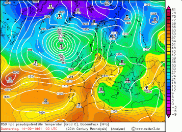
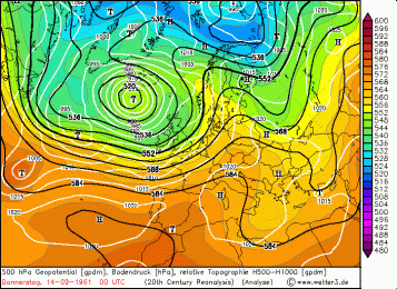
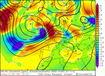
The question arises about what happened to the hurricane’s structure between the Azores and Ireland. Some say it held onto its tropical characteristics and reached Ireland somewhat intact as a tropical system. Others – myself included – believe that it had transitioned into an extratropical depression well before Ireland, deepening due to the interaction between the residual moisture and a strong upper trough. The following GFS reanalysis charts from Wetter3.de illustrate this process nicely.
00 UTC on September 14th (below): Debbie is shown as a warm-core, non-frontal tropical cyclone located in the central Atlantic (far left of chart), well to the south of the upper trough (2nd chart).
At 06 UTC on the 15th (below) it has become elongated near the Azores and has lost its symmetry (1st chart) as it interacts with the polar front and the upper southwesterly jet stream (2nd chart). Strong differential temperature advection is shown, with cold air infiltrating from the west (3rd chart). Relative humidity at 700 hPa (4th chart) shows the precipitation area (area of >90%).
00UTC on the 16th (below), a few hours before it reaches Ireland. The strong jet stream and abundant moisture have caused the depression to deepen and accelerate northeastwards towards Ireland.

The charts above, while merely reanalyses and lacking some detail, illustrate the process of extratropical transition of Debbie long before it reached Ireland. The hurricane affected the Azores as a minimal category 1 hurricane and looks to have weakened shortly thereafter. The arrival of the upper trough injected some upward forcing and reinvigorated the circulation as colder air started interacting with it from the west.
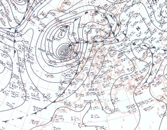
 This German analysis chart for 12Z on the 16th shows the storm off the northwest coast, with its associated cold and warm fronts. It still shows the symbol for hurricane, however, which illustrates the uncertainty that existed at the time. Note too how the strongest pressure gradient is located away from the centre.
Indeed, even today there exists some contradiction within the National Hurricane Center itself. The chart below is the official track issued by the then Weather Bureau of the U.S. Department of Commerce, clearly showing Debbie losing tropical characteristics at 40 N the day before. Other track charts show it as remaining tropical up to around Belmullet. I’m not sure how extensively this storm has been researched by the NHC to change their opinion from below, but for me this one seems about right.
The breadcrumb track also allows us to calculate the storm-centre’s forward speed as it passed along the west coast. The distance between its positions at 0600Z and 1200Z is 349 km, and this was traveled in 6 hours, yielding a speed of 58 kph.
As winds rotate anticlockwise around low-pressure systems and the whole country was located to the east of the centre we must take account of the storm’s motion when analysing the record windspeeds recorded. The 58 kph forward speed was added to the storm’s own winds to affect these areas to a greater extent than if the storm had been moving slower. Therefore in reality we must subtract some or all of this 58 kph from the windspeeds recorded below if we are to get an idea of the gradient winds generated by this 960 hPa storm. Malin Head’s minimal hurricane-force 66 knots (128 kph) sustained wind, therefore, does not constitute a true hurricane-force storm from the storm’s frame of reference. In other words, if the storm centre had been stationary the highest winds felt would have been anywhere up to 58 kph (30 knots) lower, i.e. just gale-force.

Conclusion
There have been some studies carried out on this system, but these analyse it from the observer’s or anemometer’s frame of reference. When the sustained windspeeds are analysed, yes, it was a record windstorm for Ireland and a once-in-a-lifetime event. But to answer the question of whether or not it was still a hurricane as per the tropical definition at that point we must look at it from within the storm’s frame of reference, using whatever data we have available. How fast were the winds rotating around the centre, regardless of its motion over the ground?
When we look at it this way we see that they were rotating very fast for a September storm, but well below hurricane-force 12. So regardless of whether it still had a tropical or non-tropical structure, it was really its fast forward speed adding to these winds that led to the problems witnessed on the ground.
But on that structure, both climatology and physics suggest that it could not have still had its full tropical characterstics on reaching Ireland, and I have shown that in this case the data show this transition:
● Barely still a hurricane at the Azores, weakening further but then deepening again as it interacted with the jet stream, as only non-tropical systems do.
● Loss of symmetrical structure as cold air fed into the west of the centre, forming a cold front
● Strongest pressure gradient located away from the centre, unlike tropical systems
● Very fast forward speed, well above that of tropical systems
● Relatively low rain totals for a tropical system, no doubt due to a combination of the colder air and the fast movement.
As one last suggestion I throw a possible stingjet event into the mix, as these have led to some of our strongest recorded winds in the past. Without proper satellite imagery in this case it is hard to say for sure, but the jet stream appears to have been very strong and possibly could have led to such an event, like the Fastnet Storm that killed 18 yachtsmen in August 1979.


[…] szeptemberében, a Debbie névre keresztelt vihar az Atlanti térségben 3. erősségű hurikánná erősödött, majd az […]
[…] In all, ex-hurricane Ophelia left a trail of destruction in its wake. Three people dead and almost 400,000 customers without electricity. It was an unusual storm in that it arrived from the south, losing its tropical characteristics only just before reaching the south coast. The only other storm in living memory to do the same was Debbie in September, 1961. It had been a hurricane near the Azores, though only Category 1, and only lost its tropical characteristics just south of Ireland (see here). […]